The Discovery of the sources of the Yarra
By "Field Naturalist"
Part II
After such incredible work the explorers camped east, distant about 10 miles from Hoddle's camp. The fatigue and labour of the day compelled them to consider if the journey could not be performed in a less laborious way. The result was they determine to take the river-bed, which was only about knee-deep on account of the exceedingly dry season experienced throughout the whole colony. In this manner they had often to climb a height of 40 ft. over dead trees which had fallen in great numbers across the river from either bank forming a complete barricade, the stream finding its way through the interstices. Passing Big Pat's Creek, from the same direction, shortly afterwards a beautiful affluent was noticed coming from the left, almost at right angles, with, and discharging itself into the parent stream by a forked mouth which was margined with Todeas, and a bed of graceful star-fern (Gleichenia flubellata) drooping at the foot of a solitary sassafrass tree, which, in turn was supported by Leptospermum of small elegant foliage, and under the shadow of well grown messmate gums. This stream was undoubtedly the Ligar or Bellell Creek. Shortly after leaving the Ligar, on the right some steep sidlings occur, with outcrops of schist rock rising from the river's bed. From the face of these sidlings, pretty glances were obtained of the river, purling and gurgling 80 ft. or 100 ft. below and fringed with the feathery leaves of regiments of silver wattles, here and there relieved by the darker and more intense foliage of the Myrtle (Fagus). Approaching McMahons Creek, the river takes a remarkable bend of three-quarters of a mile and comes within 40 yards of its starting-point again. Subsequently in 1864, through this peninsula of solid rock 50 ft. in height, it took four men 15 weeks to drill a ragged 6 ft. tunnel, whereby they diverted the Yarra's course. After prospecting the three quarters of a mile of the dry bed, it is related the plucky miners obtained just as much gold as cleared the expenses of the tunnelling. The explorers are now at the junction of the McMahon a clear and swift running stream about five or six paces in width. The natural bed of the Yarra here is 15 to 17 paces wide, with a depth of about 4 ft. in normal seasons, and is 1,100 ft. above sea-level. Peninsula-hill, on the right is another 1,000 ft. above the river, while opposite, across the river and the Ligar valleys, a chain of abrupt spurs attain 3,000 ft. above sea-level, and one individual, with towering timber, as if to out-do his brethren, sneaks up to 3,100 by barometer, and from that distinguished altitude frowned down on all the orgies and revelries of the hundreds of diggers that took place at McMahon's in the early sixties. Still proceeding in a north easterly direction, but before reaching what is now Reefton, a strong and rapid creek coursed in from the left, and appeared nearly equal in volume of water to the Yarra. This was evidently Armstrong's or Cumberland Creek, also shown on government maps as Meola creek. This creek is in contrast with Walsh's, a few miles on the other side of Reefton, which is of a more silent nature, with deep pools. Reefton, by nearest route is about 65 miles from Melbourne, but it would have been difficult to compute the explorer's mileage, as they kept by the winding of the river. From the junction of Armstrong's their course suddenly changed from north-east to south-east; then again to a generally easterly one. Beyond Walsh's Creek the Yarra visibly diminishes in volume, and assumes more the form of a succession of rapids. Insignificant tributaries run from either side - Wilson's Nos 1 and 2 on the left and Alderman's and Queen's Birthday Creek on the right. The mountains appeared converging on either hand towards one grand climax ahead, and dwindling river feeders, which in winter time are rugged mountain torrents, were now so many rippling rills coursing the beds of magnificent fern gullies. In fact, all the Yarra's watersheds are a perfect paradise for fern gullies more or less beautiful, but nearing the rivers main source there is an increasing abundance of aromatic-barked sassafras and fragrant-smelling musk trees, and a perfect forest of noble lofty white gums, with an entire absence of those dismal looking dead and blanched tree-barrels so conspicuous on the ranges lower down. The acme of perfection of the Yarra's scenery is undoubtedly attained among its upper waters. The glorious grandeur of the whole situation forces upon the souls of the beholders the expression of the Psalmist of old - "Oh Lord! How manifold are Thy works! in wisdom hast Thou made them all." Here the explorers stood in the primeval upland woods, with 30 or 40 miles of wild bush betwixt them and the nearest human beings, meditating on the wonderful, though silent, development of the lavish wealth of innumerable plants of rare beauty, and immense lofty trees of untold ages, in which the explorers, with every student of nature, so instinctively discerned "a still small voice." Posterity will ever revere the name of Mr. Wm. Davidson, engineer of the Melbourne Water Supply, for his far seeing policy in recommending the reservation of 120,000 acres of land lying north of Reefton, and comprising the
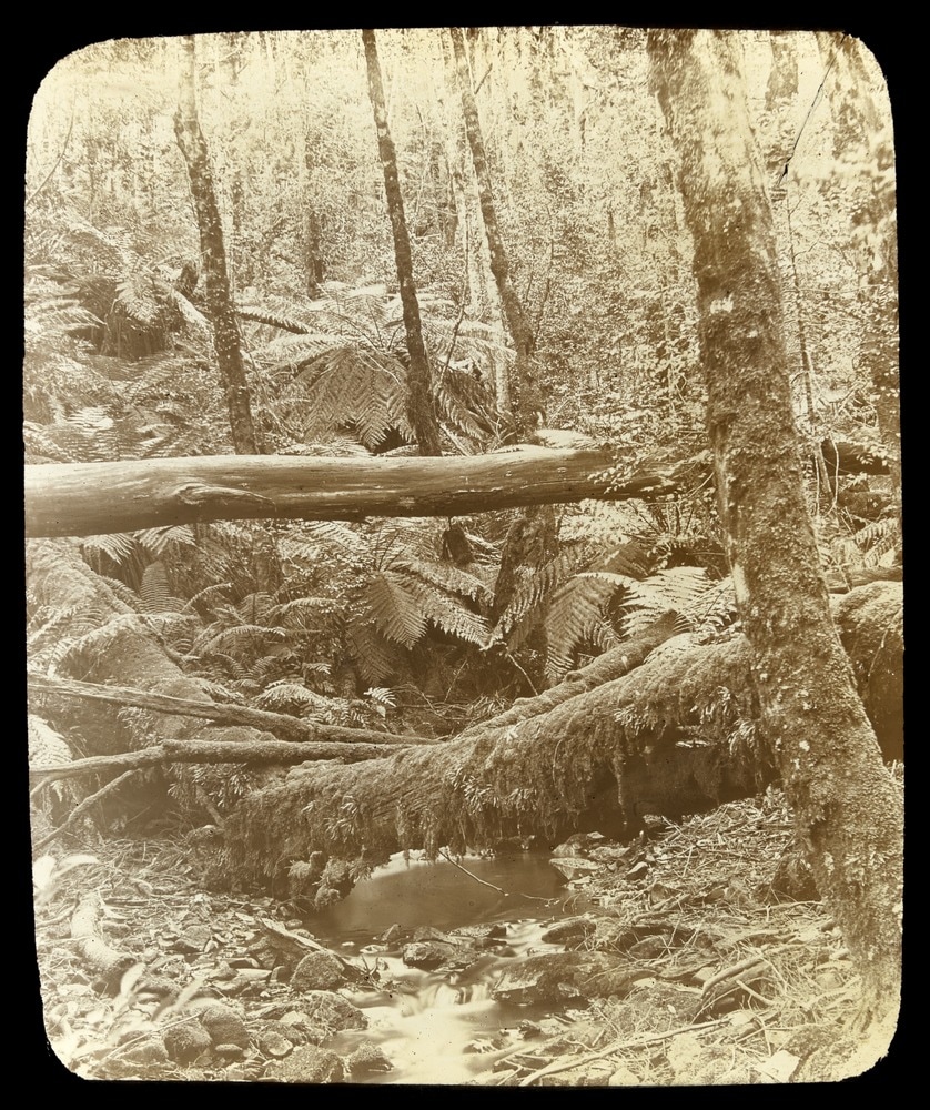
OUR SUPPLEMENT. THE HEAD WATERS OP THE YARRA.
Our artist has been happy in depicting one of the most- picturesque of the many picturesque scenes which are to be found in the neighborhood of the source of the Yarra Yarra. .To the ordinary tourist, who has been ' doing'' the various cities of Australasia, the Yarra has no pleasant reminiscences. Nor can this be wondered at. The stream as it flows through Melbourne is .minus all tho allurements which one is apt to associate with tho river of the poet's dreams and writings., Tho ' silvery sheen ' is wanting, the 'spark-ling cascades ' are not there ; and the river flows through; the heart of tho 'Queen City of tho South' muddy, sullen' and sulky. This view of tho Yarra , is not enchanting. Tar from it. -The scone which our artist has depioted,' how-ever, is in marked contrast to what we have just now described. Ho has travelled to tho sources of tho Yarra, to tho southern spurs of tho dividing range, where tho stream is yet in its infancy. Hero tho water is as pure as crystal, and rushes in joyous heedlessness onward and onward little recking that in a short space it will become thick and sullied, and flow through the heart of the city robbed of its primal chastity. Tho Yarra Yarra takes its rise in the southern spurs of tho Great Dividing Range amongst scenery of the most picturesque description. There the highest, trees in Australia, and indeed one might say in the world, make their homes. There also the gigantic fern trees grow in luxuriance, and vegetation is in the. greatest profusion. Tho droughts which are dreaded throughout tho greater portion of Australia are unknown here. Tho rains, probably on account of tho quantity of timber, are incessant, consequently, tho vegetation is almost of tropical growth. Tho scene which our' artist has happily seized upon is singularly. Australian. 'The stream, leaps from rock to rock, winding in and out, not amongst huge boulders, but between dense undergrowth and roots of trees,' fallen logs, &c. On each side of the stream, trees, tall and straight as tho masts of ships, spring out of tho ground arid rise without a bend in them to the height of 300 to 400 feet.' Ferns luxuriate on the banks and vegetation is in its seventh heaven of delight. The homo of the lyre bird is here, and, but gently be it spoken, the red deer browse in peace and quietude, and are seldom disturbed by the sound of human feet. This, too, is tho paradise of the angler, for English trout are known to abound here, though owing to the density of tho undergrowth their capture is only accomplished with the greatest difficulty. No tourist who wishes to see true Australian scenery should omit - a visit to tho Upper Yarra.
SEARCH FOR THE SOURCE OF THE YARRA
Within 60 miles from Melbourne as the crow flies is a tract of country which, hut for those imaginary lines, indicating supposi titious river streams, which geographers love to draw, would be represented on the map of Victoria by little more than a blank space. In outline shaped like a horseshoe, about 20 miles in width, and 30 miles in length, it is Burrounded by tall mountain ranges, which stretch from Marysville to St. Clair, and thence almost scmicircularly to Mount Baw Baw, from which point they continue in a nearly straight westerly direction till they be-come more or less mingled with what are com-monly known as the Dandenong Ranges. The region thus compassed about is still further hemmed in (on its western side) by the alpine ridges of whicli Mount Juliet forms a conspicuous feature ; and the circumvallation would be almost complete but for "The Gap," through which flows the River Yarra cn its way to the sea. Within the bounds thus described the head waters of the said river have their source, and it is a matter of fact that hitherto this portion of Victorian territory has been almost utterly unknown. True, a river line, with tributaries, some of which are named, appear on the map ; but, practically, no actual knowledge of any part of the main stream, or its source or surround-ings, higher than the rivulet suspiciously designated Starvation Creek, is in the pos session of the Government survey authori ties. A little is known of the river course as for as MacMahon's Creek, a few miles further up, but that is all. When many explor-ing parties were out searching for an Upper Yarra track to the Wood's Point gold-fields one or two glimpses of this sealed district were ob-tained, and what is called "Bowman's track " was traced right across it from its southern boundary to St. Clair, but the information so gathered is trifling, and for scientific pur poses comparatively vague and unsatis factory. Under these circumstances we are able to extract much that is valuable from the journals of two members of an exploring party of three who during the last few weeks of 1873 started to travel from Mount Baw Baw to the Yarra source, and, if possible, follow the river to MacMahon's Creek. We will tell their story as nearly as possible in their own
words.
It was shortly after noon on December 11 last that the party arranged their swags, shouldered them, and left the township of Tangil, en route for the summit of the Baw Baw. Each swag weighed about 28lb., and the whole lading consisted of the following articles :-Three blankets, weighing nearly 31b. each ; a small single-barrelled fowlingpiece, with ammunition ; a couple of toma-hawks; a small tent-fly, 6ft. by 6ft., weigh-ing about 3lb. ; 10lb. flour, 10lb. biscuit, 2lb. tea, 10lb. sugar, 8lb. German sausage, three pots of Liebig's extract of beef, and a bottle of cognac of warranted high cha-racter. Their route lay in the first instance up the spur dividing the rivers Tangil and Tyers, and after somewhat hard travel they camped for their first night at tho head of Bull Beef Creek, and supped off their rations. Next morning they breakfasted on grilled monkey-bear, and, following the blazes of the old geodetic survey party, made for the trigonometrical station established about 5,500ft. above the level of the sea, on nearly the highest peak of the mountain. The unlearned reader may be informed that Mount Kosciusco, the highest known mountain in Australia, is 7,200ft. high. They had not mounted far before they found themselves in altogether new country. First they met with splendid sassafras trees, which ere long they found to grow so thickly together that they could only make their way through them with diffi-culty. The overgrowth was, moreover, mingled with magnificent over-arching ferns, At Lady Manners-Sutton Creek they stopped awhile to admire a very fine belt of mountain ash, and at 6 p.m. they reached Granite Creek, which may be fairly described as in the Baw Baw ranges. Here they saw trees the ascertained height of which was 350ft, and the trunks of some of them measured 80 links or about 53ft. in circumference. Next day found them on Baw Baw summit, on ?which they camped, for the atmosphere was so thick with mist and smoke from bush fires that they could get no cloar outlook. During the night the wind changed from north to south, and the mountain top was thenceforward till the following noon en-veloped in rolling clouds of dense volume, which drenched the poor explorers to the skin. At last the prospect cleared, and a vast and magnificent panorama unfolded itself. To the south-east were the Gipps Land lakes, to the south the apparently end-less Hoddle ranges, where
"Hills peeped o'er hills, and Alps on Alps arose."
To the south-west lay Western Port Bay and Bass's Straits; to the westward Arthur's Seat, Mount Eliza, Mount Martha, Hobson's Bay, and Station Peak ; to the northward, the township of Red Jacket (the roof of the schoolhouse, which forms the almost sole remnant of burned-down Matlock, could be discerned gleaming in the sunlight) ; and to tho north-east, the great ranges of North Gipps Land. They found the timber on Baw Baw to comprise the stunted mountain ash, myrtle or mahogany, and thick scrub, mostly Erica.
The party had now a somewhat puzzling question before them for they were required to decide in what direction they would begin their search for the Yarra source. In the ranges on which they stood rises not only the Yarra but the Tangil, the Tyers, and the Latrobe, and there was danger of mistake. They knew, moreover, that the gullies were numerous and that surrounded as they were by mountainous heights covered with tall trees, they would never get another view of the lay of the country thoy had to traverse. Eventually, taking Matlock as their bearing for a start, they shaped a course down hill N.N.W. for about three miles and a half, and then N.W. for about a mile and a half further. At that point they came across the first of a series of mossy flats covered with a scrub which they arbitrarily denominated "lurcher", after their dog, whom they often hiad to carry over the worst portions of the ground. Such a companion could not have been a comfort. Underfoot the earth was soft and spongy and clothed with what looked like spergula. It was obviously one of the mossy flats that contribute to the head waters of the rivers that rise in these parts, but whether the particular stream in question was that of the Tangil or the Yarra was not clear. Patient observation enabled the travellers to decide the point, which was completely settled when they found themselves on a steep range over looking both rivers. This discovery was made on the second day after they left Baw Baw, viz., Thursday December 18 and they soon afterwards pitched their camp for the night delighted with their success and ter ribly tired by their journey through granite boulders and dense scrub The latter was found an abomination and for want of a better name they dubbed it Crevecoeur scrub, for its leaves grew the wrong way, and its prickles were sharp, reminding them of the Crevecoeur breed of poultry. Their resting place was a romantic spot between two huge boulders, and at the head of a sparkling little rill which ran into the valley below. Beneath them lay the object of their search-the Yarra. The river bed was a deep gorge, in which granite boulders were so jammed as to cause the waters to make any number of charming little cascades. The whole scene was arched in by sassafras and myrtle trees. As they could see no gigantic ferns, the party concluded that they were still some 4,000ft. above the level of the sea. According to
their view the main stream of the Yarra takes its rise from a small plain or flat, several acres in extent, thickly carpeted with the spergula-resembling moss already alluded to, and dotted here and there with water-holes. The spot was almost surrounded with hills capped with granite, from whence the water was found to percolate and be carried down to a well-defined watercourse, which gradually increased in size as it was joined by numerous other rivulets similarly derived from the surrounding watershed, until it became a deep and rapid stream in the valley below. Gazing on the spectacle before them, the members of the party felt convinced that they were the first white human beings to witness it.
The exact order of the events which hap-pened to the party during this and the succeeding few days is not clear, for the memoranda before us are somewhat confused. The explorers seem to have en-deavoured to bear N.W., and crossed nume-rous streams, all running into the Yarra. Their path was extremely difficult to traverse, and occasionally they would get on for 300 yards or so without touching the ground, but picking their way along long lines of dead timber, and supporting them-selves by holding on to the scrub on either side. To make matters worse, the rain often descended in torrents, drenching them, and it cost them no small portion of their time to sit down and patch up their torn gar-ments with pieces of blanket. Tree leeches, too, dropped upon them as they plodded on, and-to quote the words of one of the party-"tapped our persons in various parts," There is no need to describe in detail these and other hardships which the party en-dured, or how they had for miles together literally to cut their way through the scrub with their tomahawks. They crossed the Yarra several times, and as their course lay down the stream they found it to grow more deep and rapid as they proceeded. In one part it ran for over 100 yards in a series of cascades among granite boulders richly covered with moss, while lovely ferns mingled their frondes ucross the water. On Decem-ber 21, having just encountered a fearful storm of rain, which thoroughly wetted them, they found themselves in a splendid valley, where they discovered what they con-ceived to be the remains of an old prospect-ing camp. By observations which they took from a neighbouring peak, they ascertained that this valley extended a considerable dis-tance to the S. and S.E. The land appeared excellent for agricultural purposes, the soil being dark and rich, the grass luxuriant, and timber very scarce, but it was evidently extremely difficult of access, for it was hemmed in with dense scrub on both sides. The peak from which the observations were made was found to be capped with ironstone, and the reef seemed to run about N. 10° W. (magnetic). The neighbouring ranges gave strong indications of being auriferous, and in an N.W. direction were several creeks with slaty bottoms, presenting a gold-bearing appearance.
Here our story closes. The party having got to within 15 miles of MacMahon's Creek, found their provisions too short to allow them to reach it, because owing to the difficulty of the country and density of the scrub, the journey would have occupied many days. So, on December 23, they changed their route to a more northerly course, made up the range which forms the divide between the Goulburn and Yarra head waters, and struck again to the N.W. until they found themselves on the Wood's Point track. This they followed until they roached a shanty 30 miles from Marysville. Their route was then clear. They got to Marys-ville in time for their Christmas dinner, and on the morning of the 26th the coach brought them into Melbourne.
THE SOURCE OF THE YARRA.
TO THE EDITOR Of THE ARGUS,
Sir,-It appears to be not generally known that the River Yarra Yarra was traced to its source 31 years ago by a gentleman in every way practically qualified for the task. The following particulars were mode known in a newspaper published by me in Melbourne at that time, and though it has subsequently appeared in the pages of my "Early History of Victoria," it will no doubt, if transferred to tho columns of the Argus, be read with interest by thousands of individuals who have not hitherto had an opportunity of perusing them:-
"The Source of the Yarra Yarra - Whilst the Government was making futile attempts to trace the source of the Yarra Mr Walpole, who was a practical surveyor by profession, but at that time had, in conjunction with Mr. Goggs, a dairy station near Melbourne undertook the exploit. The following article appeared in the Standard of 12th March, 1845, which we are sure will be read with interest by every one. It deserves an imperishable place in the early history of the colony as a feat of private enterprise and personal curiosity, combined with laudable ambition, overcoming difficulties and impediments which the Govern-ment failed to surmount, and accomplishing a task redounding to the credit of Mr Walpole and his brave companion. The Yarra rises in a gully between the Snowy Mountains and one of the Goulburn mountains about 100 miles distant from Melbourne as tbe crow flies, and commences to flow to the south east, from which direction its nume-rous tributaries also flow. The spring, the river's source, is so small that it could run through a 4in pipe. It is fed about midway on the south side by six tributaries and four or five on the north side, they are situate upon an average about three or four miles apart. After each tributary the size of the river decreases considerably These branch streams rise in the gullies adjacent and some of them are of great magnitude The country beyond Rirey' s Station is one mass of scrub. With one of Mr Protector Thomas's sons, Mr Walpole left Rirey's Station on horseback, but found it impossible to make any progress not only from the density of the scrub but the utter absence of vegetation or any feed for the horses. They accordingly had to retrace their steps and leave the horses behind them. They a second time started on foot, and walked for five days in the bed of the river through 2ft and 3ft of water. In this course they had often to climb a height of 40ft over dead trees which had fallen in great numbers across the river from either bank forming a complete barricade, the stream finding its way through the interstices. Gum, ironbark, and other timber have here grown to an extent in altitude and circumference unseen in any other portion of this province, while many of the plants indigenous to tropical climates have been discovered, and amongst others, a shrub in every particular resembling the coffee plant with a large red berry the size of a cherry, which, being exposed to the sun, becomes quite hard and black, also, a large aromatic berry bearing every resemblance in appearance and taste to the black pepper berry but with a flavour as pungent as cayenne From these indications there can be little doubt but that innumerable tropical fruits of this description cover the face of the interior of this continent. The sassafras and musk plants exist in great abundance. The land is well watered, but of open country scarcely one square yard was visible The river the whole of the way up is as clear as crystal and where not covered with dead trees a clear pebbly and rocky bottom is distinguishable. About 17 miles from the source an abundance of good slate exists and will split into plates of an eighth of an inch in thickness. The only birds seen were pheasants or lyre birds and they appeared in multitudes. No recent tracks of the natives were discovered, but a few barked trees leading from Gipps Land to one of the tributaries were observed a few miles below the source of the river, they appeared to have been barked some three or four years back. The Yarra is described as singularly tortuous at one point running for two or three miles direct South and then to on equal distance full north.
The position of a tree near the source, on which Mr. Walpole cut his initials is marked on the Government maps -Yours,
T. STRODE,
Punt-road, Richmond.

 RSS Feed
