THE ROCK (BEN CAIRN) AND DONNA BUANG
My heart turns to high places...
—Dorothea Mackellar.
The first generation of our native-born not only "learnt from their wistful mothers to call old England 'Home,'" but many of them gathered from over-patriotic fathers the conviction that everything was immeasurably greater or finer in the British Isles than anything Nature could produce here. The mavis and the lark sang across the years songs that were sweeter by far than those which the magpie and the harmonious thrush were pouring forth so liberally, the scent of the violet was richer, at least in remembrance, than that of the wattle or boronia. Particularly were the prominent features of the landscape slighted: there was no creek to compare with the English brooks and the Scottish burns, while the hills which had towered so high to their childish eyes seemed in retrospect to overtop with ease the mountains of this new land.
A Brother of Ben Nevis.
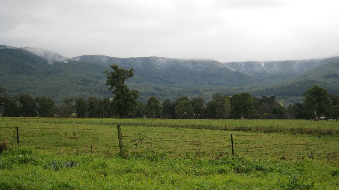
Thus many a young Australian realises with surprise that there is at least one peak within fifty miles of Melbourne which is higher than anything in the United Kingdom, with the solitary exception of Ben Nevis. Donna Buang is 4080 feet, so the Scottish mountain can give it but 400 feet at the outside. The late Mr. J. A. Panton is said to have discovered it in 1865, and he is held responsible for the name. It stands very little higher than the huge huddle of hills of which it forms a part, and it has no striking features to mark it out on the skyline. But it gives a magnificent outlook. About five miles away to the west is Ben Cairn (better known as The Rock), also a place of noble views, and these two high points form a natural pair for the walker to visit who has a week-end at his disposal.
There are several ways of attacking them, the one thing common to all being a long pull up. On most of these the walker will be the happier if he has had sprigs or nails put in his bootsoles to give him grip, and he should not neglect his leggings. The conventional mode of reaching the top of Donna Buang is to drive from Warburton to the horseshoe bend on Cement Creek, and walk along the well-graded track which ends on the summit, in all about 12 miles. As a winter trip, with snow on the ground, this is fairly severe, but the long days and dry tracks of summer make it easy enough. A more direct route is up the timber tracks from Warburton. They may be readily found by local inquiry. They cut the distance down to five or six miles, but they can be recommended to the young and sturdy only. The walk could continue across to Ben Cairn (five or six miles), down to Millgrove (four miles), and "so home," as Mr. Pepys used to say.
That would make a very full day, but the excellent tourist road which now connects the two peaks provides quite good going.
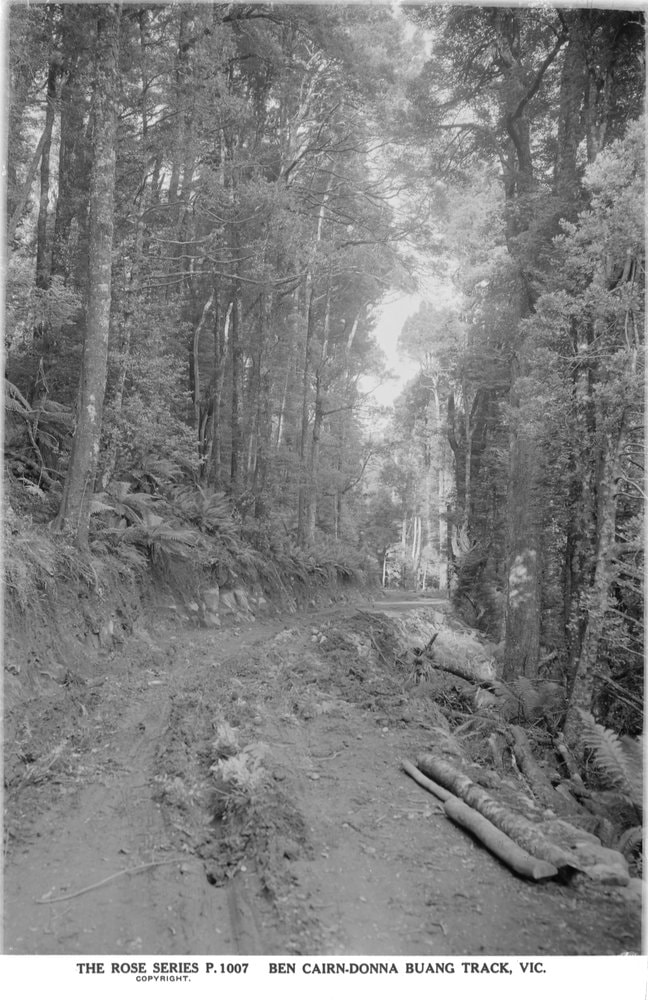
Timber Track Near Warburton
Swag and Sleeping Bag.
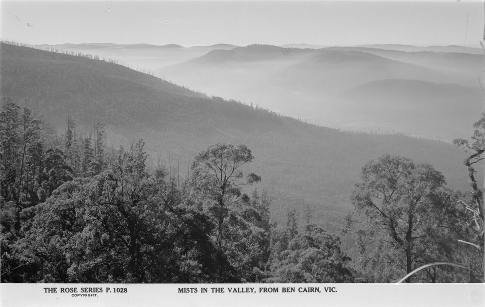
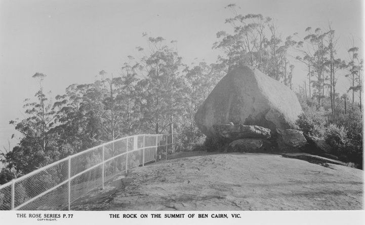
In reverse order the trip just outlined could be comfortably accomplished if one cared to carry a swag or sleeping bag. Sleeping bags were difficult to obtain during the period of the war, but now that things are back to normal the shopkeepers will no doubt stock them again. With a swag of some kind and tucker enough for three meals, Ben Cairn may be climbed from Millgrove on a Saturday afternoon, a camp made just at the back of the big rocky outcrop which distinguishes this peak, and on Sunday Donna Buang may be crossed and Warburton reached in time for the evening train. Night on the top of the Rock, in good weather, is an experience worth all the trouble of reaching there. Above are the stars, very bright at this altitude of over 3000 feet, and beneath is another heavenfull, for the great basin of the Yarra, walled on both sides by mountains, is directly below, and is sprinkled with little townships, each township holding a handful of lamps, many of them electrically lighted.
Other Approaches.
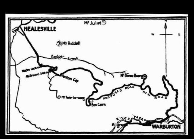
Coming from Launching Place the Don Valley road gives good approach to a well-cut track that goes off easterly at Panton's Gap and ends at the Rock. But better still, in the writer's opinion, is the walk from Healesville which takes in portion of this route. It provides two pleasant strolls, and there is no need to camp out. The afternoon train on Saturday is early enough to permit of leaving the township by 3 o'clock. The Don Road, which must be followed, is not uninteresting at any point, and as it dips to the Badger Creek it is beautiful. Some very fine samples of Christmas bush mark the rise on the far side, and, about a mile on, there is a short cut which is worth taking. It turns to the left near a house. Its steepness is modified by the outlook it gives, and it saves some very long bends in the coach road. A little further on a finger post directs to Malleson's Look-out, commanding a prospect of much charm, and soon the guest house of this hillside (really Mount Tooleybewong) comes into view. It is known as "Nyora," and is about nine miles from Healesville.
The Paddock Track.
Next morning there are more views to admire before the paddock track is sought. This should be inquired for. It meanders along hillsides, until it drops suddenly to the Launching Place Road near a large signboard bearing directions regarding Ben Cairn and Donna Buang. This is Panton's Gap, with Panton's old house still standing in a grove of walnut and chestnut trees. Long sidings over the Badger Valley succeed until the crossing of a saddle changes the slope to a southerly one. Excellent valley peeps are obtained. At a convenient time the Don races under the track in a corner where there is a sharpish turn. Later this bustling stream may be seen again by going a few hundred yards off the beaten way. Some Aberdeenshire man was evidently in this part of the country when names were being given, for the three main streams of the locality are the Dee, the Don and the Ythan. The growths are more striking as the way ascends, and in the proper season may be seen, in all their native beauty, the fine blooms of the Eriostemon and the mintbush, both now well-established garden favorites. Little runnels make a pleasant coolness, and at the last of these the billy should be filled, for there is no spring on the summit. There is water, however, within ten minutes, in a line directly behind the Rock.
Timber Slide and Tram Track.
To continue on to Millgrove from the top of Ben Cairn, one must follow the Donna Buang pad northwards to where it first divides. The branch to the right, turning sharply back and running under the Rock, is the correct one. When I was last there it was badly overgrown, and probably it still needs clearing. Its general inclination is to the right, until it slips down a short timber slide on to an old tram track by a creek. The tram track makes fair walking, and it may be kept as far as the aqueduct. By turning to the left along the bank of this channel excellent going will be found. It joins a road which crosses the Yarra at its junction with the Dee, close to Millgrove, which has a railway station. An alternative is to continue along the Donna Buang Road till, just past a beech grove, a saw mill winch is visible. To follow the mill tracks down is to go direct to Millgrove.
Still another pleasant way from Healesville calls for the use of a swag, and for the strength to do a strenuous day on foot. Make the Badger Creek on Saturday afternoon, camp the night there, and, just above the bridge, pick up the boundary track of the Metropolitan Board's reserve. It is small and may not be well-defined, but after it has reached the top of the divide by a breathless zig-zag there are no severe pinches. When it reaches Donna Buang the final stage may be completed on the main road from Warburton. En route Ben Cairn could be visited. To do this trip one must keep going. It would be more pleasant on a week-end, with a Monday holiday. A night could then be spent on the Badger, and another on the Rock, and there would be ample time to admire the scenery and listen to the lyre-birds, for which these particular mountain-tops are famous.
My heart turns to high places...
—Dorothea Mackellar.
The first generation of our native-born not only "learnt from their wistful mothers to call old England 'Home,'" but many of them gathered from over-patriotic fathers the conviction that everything was immeasurably greater or finer in the British Isles than anything Nature could produce here. The mavis and the lark sang across the years songs that were sweeter by far than those which the magpie and the harmonious thrush were pouring forth so liberally, the scent of the violet was richer, at least in remembrance, than that of the wattle or boronia. Particularly were the prominent features of the landscape slighted: there was no creek to compare with the English brooks and the Scottish burns, while the hills which had towered so high to their childish eyes seemed in retrospect to overtop with ease the mountains of this new land.
A Brother of Ben Nevis.
Thus many a young Australian realises with surprise that there is at least one peak within fifty miles of Melbourne which is higher than anything in the United Kingdom, with the solitary exception of Ben Nevis. Donna Buang is 4080 feet, so the Scottish mountain can give it but 400 feet at the outside. The late Mr. J. A. Panton is said to have discovered it in 1865, and he is held responsible for the name. It stands very little higher than the huge huddle of hills of which it forms a part, and it has no striking features to mark it out on the skyline. But it gives a magnificent outlook. About five miles away to the west is Ben Cairn (better known as The Rock), also a place of noble views, and these two high points form a natural pair for the walker to visit who has a week-end at his disposal.
There are several ways of attacking them, the one thing common to all being a long pull up. On most of these the walker will be the happier if he has had sprigs or nails put in his bootsoles to give him grip, and he should not neglect his leggings. The conventional mode of reaching the top of Donna Buang is to drive from Warburton to the horseshoe bend on Cement Creek, and walk along the well-graded track which ends on the summit, in all about 12 miles. As a winter trip, with snow on the ground, this is fairly severe, but the long days and dry tracks of summer make it easy enough. A more direct route is up the timber tracks from Warburton. They may be readily found by local inquiry. They cut the distance down to five or six miles, but they can be recommended to the young and sturdy only. The walk could continue across to Ben Cairn (five or six miles), down to Millgrove (four miles), and "so home," as Mr. Pepys used to say.
That would make a very full day, but the excellent tourist road which now connects the two peaks provides quite good going.
Timber Track Near Warburton
Swag and Sleeping Bag.
In reverse order the trip just outlined could be comfortably accomplished if one cared to carry a swag or sleeping bag. Sleeping bags were difficult to obtain during the period of the war, but now that things are back to normal the shopkeepers will no doubt stock them again. With a swag of some kind and tucker enough for three meals, Ben Cairn may be climbed from Millgrove on a Saturday afternoon, a camp made just at the back of the big rocky outcrop which distinguishes this peak, and on Sunday Donna Buang may be crossed and Warburton reached in time for the evening train. Night on the top of the Rock, in good weather, is an experience worth all the trouble of reaching there. Above are the stars, very bright at this altitude of over 3000 feet, and beneath is another heavenfull, for the great basin of the Yarra, walled on both sides by mountains, is directly below, and is sprinkled with little townships, each township holding a handful of lamps, many of them electrically lighted.
Other Approaches.
Coming from Launching Place the Don Valley road gives good approach to a well-cut track that goes off easterly at Panton's Gap and ends at the Rock. But better still, in the writer's opinion, is the walk from Healesville which takes in portion of this route. It provides two pleasant strolls, and there is no need to camp out. The afternoon train on Saturday is early enough to permit of leaving the township by 3 o'clock. The Don Road, which must be followed, is not uninteresting at any point, and as it dips to the Badger Creek it is beautiful. Some very fine samples of Christmas bush mark the rise on the far side, and, about a mile on, there is a short cut which is worth taking. It turns to the left near a house. Its steepness is modified by the outlook it gives, and it saves some very long bends in the coach road. A little further on a finger post directs to Malleson's Look-out, commanding a prospect of much charm, and soon the guest house of this hillside (really Mount Tooleybewong) comes into view. It is known as "Nyora," and is about nine miles from Healesville.
The Paddock Track.
Next morning there are more views to admire before the paddock track is sought. This should be inquired for. It meanders along hillsides, until it drops suddenly to the Launching Place Road near a large signboard bearing directions regarding Ben Cairn and Donna Buang. This is Panton's Gap, with Panton's old house still standing in a grove of walnut and chestnut trees. Long sidings over the Badger Valley succeed until the crossing of a saddle changes the slope to a southerly one. Excellent valley peeps are obtained. At a convenient time the Don races under the track in a corner where there is a sharpish turn. Later this bustling stream may be seen again by going a few hundred yards off the beaten way. Some Aberdeenshire man was evidently in this part of the country when names were being given, for the three main streams of the locality are the Dee, the Don and the Ythan. The growths are more striking as the way ascends, and in the proper season may be seen, in all their native beauty, the fine blooms of the Eriostemon and the mintbush, both now well-established garden favorites. Little runnels make a pleasant coolness, and at the last of these the billy should be filled, for there is no spring on the summit. There is water, however, within ten minutes, in a line directly behind the Rock.
Timber Slide and Tram Track.
To continue on to Millgrove from the top of Ben Cairn, one must follow the Donna Buang pad northwards to where it first divides. The branch to the right, turning sharply back and running under the Rock, is the correct one. When I was last there it was badly overgrown, and probably it still needs clearing. Its general inclination is to the right, until it slips down a short timber slide on to an old tram track by a creek. The tram track makes fair walking, and it may be kept as far as the aqueduct. By turning to the left along the bank of this channel excellent going will be found. It joins a road which crosses the Yarra at its junction with the Dee, close to Millgrove, which has a railway station. An alternative is to continue along the Donna Buang Road till, just past a beech grove, a saw mill winch is visible. To follow the mill tracks down is to go direct to Millgrove.
Still another pleasant way from Healesville calls for the use of a swag, and for the strength to do a strenuous day on foot. Make the Badger Creek on Saturday afternoon, camp the night there, and, just above the bridge, pick up the boundary track of the Metropolitan Board's reserve. It is small and may not be well-defined, but after it has reached the top of the divide by a breathless zig-zag there are no severe pinches. When it reaches Donna Buang the final stage may be completed on the main road from Warburton. En route Ben Cairn could be visited. To do this trip one must keep going. It would be more pleasant on a week-end, with a Monday holiday. A night could then be spent on the Badger, and another on the Rock, and there would be ample time to admire the scenery and listen to the lyre-birds, for which these particular mountain-tops are famous.
Argus (Melbourne, Vic. : 1848 - 1957), Wednesday 18 June 1924, page 19
BEN CAIRN TO DONNA BUANG. DAMAGE TO ROAD.
Forests Commission to Act.
The attention of the chairman of the Forests Commission, Mr. Owen Jones was directed yesterday to complaints
regarding the damage that is being caused by saw-milling operations to the road between Ben Cairn and Mount Donna Buang. Mr. Jones admitted that the road was being severely damaged by the haulage of logs across it, but said that the commission could not be held responsible.
The sawmiller whose operations had given rise to the complaint, Mr. Jones said, had been granted a lease on the timber area many years ago. He had sunk a large amount of capital in plant, had paid hundreds of pounds in freight to the Railways department, and large amounts in royalties for timber. He kept about 24 men in continuous employment. Comparatively recently the Tourist committee had constructed the road through the area, but had neither consulted the commission before doing so nor given the commission any notification of its intention. Consequently the commission was placed in a false position regarding the complaint. To dispossess the sawmiller or to cancel his contract would involve him in a very serious loss. It would also require a considerable expenditure to install plant which would make it possible for him to haul his timber above the road. After consultation with the Tourist committee the Forests Commission had decided to assist the sawmiller by providing such plant, and an attempt was being made to obtain it. Though efforts had been unsuccessful up to the present, the commissioners were confident that the plant would be installed and the road repaired in time for any tourist traffic there might be in the coming spring.
The Argus Sat 22 Mar 1924 Page 10
BEN CAIRN AND DONNA BUANG
TIMBER PERMITS GRANTED
DEPARTMENT OF WORKS IN OPPOSITION
( BY OUR SPECIAL REPORTER )
( No 2 )
No one will deny that timber milling is a necessary function of society, and a welcome source of revenue to the State. In some circumstances it is even possible to regard the sawmiller as the forerunner and advance guard of civilisation. But not always. There is still a considerable area of Victoria where milling may be pursued with advantage, and it is competent to object to the invasion of the other areas which possess marked scenic beauties. Obviously the country between Ben Cairn and Mount Donna Buang form such an area.
At considerable cost the Public Works department is just completing a road to join theses two high mountain peaks. As told in a previous article, the route of this road is along the south side of the Ben Cairn - Donna Buang range, and it opens up, within striking distance of Melbourne, several miles of unexcelled mountain scenery. The run which it will provide should be deservedly popular with motorists, being both beautiful and convenient. Everything, then would seem to be so but for the policy of the Forestry Commission. Maybe it is too much to expect that one Government department should take official cognisance of what another is doing. At any rate, inexplicable as it may seem, the forestry authorities are allowing a milling company freedom to destroy the fine scenic forest which the road exploits. In return, of course, the State receives a few hundred pounds in royalties on the felled timber. For this, an asset worth immeasurably more is in danger of total destruction. At once on the range side two sounds may be heard. One is the clang of the men completing the road as they prepare to blast rocky projections on the last section out of the way. The other is the loud rattle and discordant whistle of the hauling plant as forest giants are brought in.
THE AFFECTED AREA
Soon after passing the summit of Ben Cairn the new road enters a forest of beech vegetation of limited extent, only found on the southern ranges of the State. About a mile and a half on the eucalypt resume control, chiefly the stately, clean stemmed mountain ash ( E. regnans ). At this point the tourist looks down on a scene of desolation, showing how completely sawmilling has done its work. Hardly a tree of any size is left standing on the broad ridge that runs down to the base of the range. The milling has been done under the auspices of the Forest Commission, which has now decided to permit the cutting down of timber between the road and the summit of the the range along which it runs. The commission, it is announced, only intends to sanction "thinning out" so as to let the forest go on growing; but first you cannot fell big trees without destroying surrounding vegetation, and as the miller hauls away only 20 ft. of the bole, the ground is left encumbered with a confused mass of upper stems, big boughs, and foliage, which are sometimes got rid of by setting them on fire. Where the miller operates by the acre with bush fires destroy by the square mile, as the present appearance of the ranges amply testifies. Next, the timber which it is proposed to fell can only be transported to the base of the range by sliding huge logs across the new road, and application has been made for leave not only to cross the road with a slide, but to run a tramway along it.
The difference in level between the road and the summit of the range is about 300 ft. Is it worthwhile, merely to get at so narrow a belt, to extend forest stripping upwards to the top? The Forest Commission is in statutory charge of the ranges hereabouts, and for the sake of raising revenue can permit as much destruction as it pleases, without regard to the effect which may be produced on the scenery. Yet it must know that for several years past the Public Works department under a far seeing Minister has been steadily carrying out a scheme for making the run over the Ben Cairn and Donna Buang Ranges the metropolitan showplace of Victoria - a showplace to advertise the State far and wide. The least the commission could have done would have been to consult the Works department before issuing a permit which must involve not only the creation of an eyesore, but interference with the safety and free use of the road.
But that is not the end of the story. In some cases after the retirement of the sawmiller from the mountain slopes and slides he makes are converted into gullies, and wherever he fells a big tree the hauling away of the part he wants begins a U-shaped channel. On the Don Range last year after only three or four weeks milling, in February, slides were formed which heavy rains occurring a few months later converted into gullies five and six feet deep. Previous to the milling the natural vegetation had prevented any special rush of water and the drainage was restricted to well protected streams. What the Ben Cairn to Donna Buang road will look like a year hence when the storm waters come down by a new series of artificial channels, cutting across it, is an interesting question. Unfortunately the Public Works department hitherto has taken very little care of the mountain road and tracks after forming them. In due time trees fall across them, and storm water transform tiny ruts into ugly channels, which make driving a difficult if not dangerous business. Uninvited vegetation, too, proceeds to encroach on and narrow the track. A new policy of spending a little money annually in keeping mountain roads and tracks in repair is to be hoped for.
The Argus St 6 FEB 1926 Page 8
BEN CAIRN BY MOONLIGHT
VANDALS TEAR UP TREE-FERNS
By A. W, DAWES
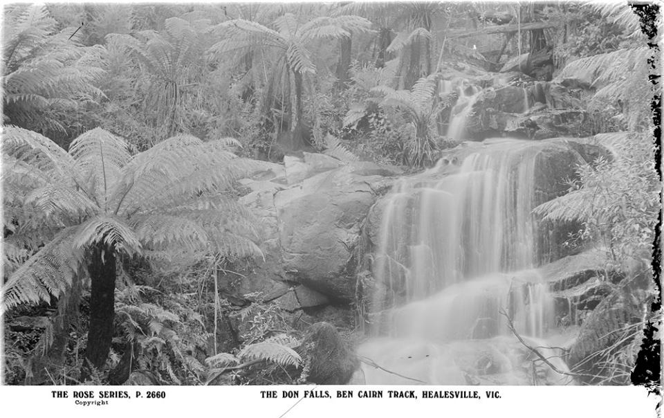
Always popular with motorists and the long distance walkers the Healesville-Warburton district has become much more so since the road from Ben Cairn to Donna Buang was opened. Mount Donna Buang was formerly easily accessible from Warburton and Ben Cairn, and comparatively so from Healesville, but the new road makes possible a through trip of the greatest charm and interest, as many pedestrians and motorists found on taking the road at the Federation Day holiday weekend. The increasing popularity of the district however, makes all the more necessary the exercise of keen vigilance to prevent the spoliation of the beautiful fern glades. The road has not been open for two weeks, and already vandals have been at work. If their depredations continued unchecked, the mountains and gullies, which are now a glory of glistening fronds will be stripped as bare as some of the slopes of Fern-tree Gully. On Foundation Day car followed car down the mountain side laden with ferns of every description. Some had huge tree-fern boles lashed to the rear bumper, pilfered apparently in utter disregard of the fact that the greatest care is required to transplant them. Others, again, had the seats piled high with fishbone fern and cat fern and other smaller varieties. Motorists were to be seen shamelessly removing ferns from the very roadside. Whether some hid their ill-gotten booty before they removed it, it is impossible to tell, but certainly many made no attempt at concealment.
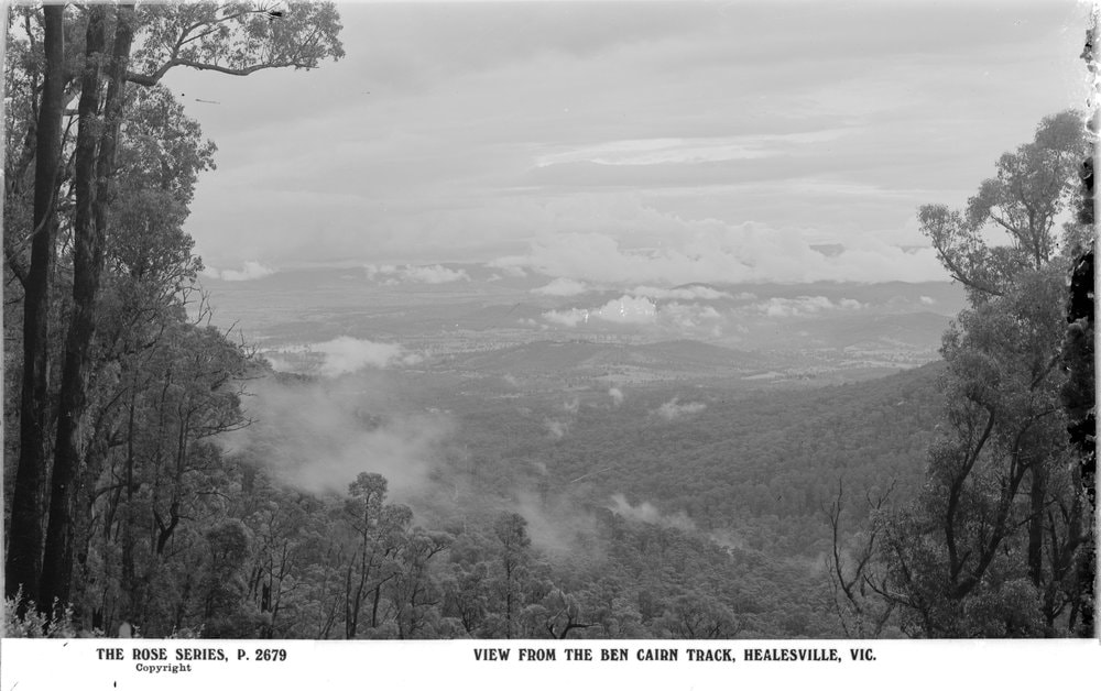
It is difficult to imagine a more beautiful walk than that over the Ben Cairn road on a night when the moon is at the full. Several parties were on the road at the last full moon, which coincided with the Foundation Day holiday. Some walked from Warburton, but probably the better route is that from Healesville. Leaving the railway station in the afternoon the walkers climbed by easy stages the 2,300 ft. to Don Gap, picnicking at tea time where the Badger Creek rippled over the cobbles, and halting a little while at Malleson's Lookout to peer vainly through the pall of smoke for the glorious view of Monda, behind Mount Riddell, which the Tourist Bureau promises and the bush fires forbid. Supper was hot soup in the light of the campfire built on the shelter of the rocks where a little cascade purls gently beneath a bridge to a fern forest only faintly discernible under the smoke-veiled stars. Although it was midnight the moon still lurked behind the black bulk of the mountain. Presently however, the moonlight advanced slowly down the path, and the fern-trees, decked in its white and blue, shone out in descending ranks in the gully. The walkers shouldered their haversacks and advanced to meet the moon, which, once they had rounded the bend, hung in the sky before them.
Thence the road rose into the smokey Divide. To right and then to left gigantic white trunks of mountain ash reached out of unfathomable depths of smoke fog from valleys that dropped down in sheer obscurity. From gaps which on a clear night command a view right beyond the bay nothing could be seen but island mountain peaks above billows of smoke. The road lay through lanes of ferns, and sometimes like a rain of bridal blossom the little flowers of the mountain lilac - "Christmas bush" - draped in scented cascades. Ben Cairn itself shut out the moonlight as the road wound through gloomy avenues of gums opposite Mount Toolebewong, but appearing round another bend the moon lit up the little signpost "To the Rock" which indicated the rough bush track that leads up to the summit from the beaten way. A stiff climb of about a quarter of a mile brought the walker up to the great stone pinnacle which gives the name to the mountain. From the queer natural platform under the rock, leaning out over the iron railing, they looked down the misty glen, where in the Shadow of Donna Buang's 4,050 ft. the Dee River faintly glittered, while beyond a red dragon of bush fire flame, at the foot of the mount, shone menacingly through the haze. Its hot breath, on the east wind, brushed their cheeks. Dawn was just picking out the figure of Donna Buang with the faint halation of pink when they threw themselves down to sleep in the shadows of the Rock. A few hours later they were tramping down the track to breakfast at the nearest water - about Clarke's Gap.
By Sunday night they had covered 24 miles, and had reached the summit of Donna Buang, walking in the shade of tall beeches, green and gnarled with festoons of clinging creepers, which hung down to the arching fronds of the tree-ferns, with distant hills only faint through the fire mist. From the top of Donna Buang, as from Ben Cairn's stone roof, the glorious vista over the timbered ranges resolved itself into an archipelago of summits and a sea of smoke surging round the tinted atolls of the nearer hills. In contrast with the straight trunks of the sheltered valley forests, the trees on the summit of the highest mountains were grey and gnarled, and stooped like old men. The Lookout is a decrepit wooden structure, carrying a scarcely perceptible warning that it is dangerous if occupied by more than four persons at once. Its rotten timbers give a clearer admonition that it is many years past the firewood stage. Snug in waterproof sleeping bags the trampers suffered nothing from the wet mists which swept over their faces as they slept out under the summit, and they were early on their way next morning to walking their last 11 miles down into Warburton. The fragrance of the beech came fainter, and they felt the exhilaration of the mountain gradually deserting them as one after another they left the forest reaches and the gullies behind them. Like a belated echo, the call of the lyrebirds mocking the noise of the fall of the axes was heard as they passed the timber tram, and the mount was alive from summit to foot with the music of the birds.
The last roadside meal was a camp lunch in the cool bower at Cement creek, where the Marysville road branches off in the north. Soon, like a postcard landscape, with its crossword puzzle, fields in alternating green and brown, and its toy township scattered along the banks of a river too pretty to be real, Warburton came into view, and the trek was over.

 RSS Feed
